TAAWA TRAIL
 |
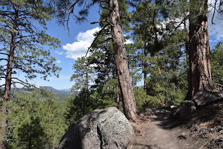
| A steep drop-off on the Taawa Trail |
One of Flagstaff’s newest hiking routes is destined to become an Arizona high-country classic.
Completed in the fall 2024, the Taawa Trail is the last trail to be built in Flagstaff’s Mount Elden-Dry Lake Hills (MEDL) area and is one of the few designated for hiker-only use. The challenging yet approachable path seamlessly melds easy mountain traipses with aggressive climbing.
 |
| A survivor Alligator Juniper on the Taawa Trail |
It’s kind of like eating ice cream with habanero sauce.
The close-to-town MEDL trail system has been popular with non-motorized trail users since its debut in 1987. In addition to its recently expanded menu of new stacked loops, the area also shares space with the Arizona National Scenic Trail and the Flagstaff Loop Trail.
 |
| Volcanic boulders line the Taawa Trail |
 |
| View of the San Francisco Peaks from Taawa Trail |
Trail planning, design and construction was a hyper-local effort with contributions from the U.S. Forest Service Coconino National Forest Flagstaff Ranger District, American Conservation Experience, and many volunteer hours and fundraising events organized by local bike organizations and local businesses.
 |
| The Taawa Trail is for hikers only |
The results are breathtaking. New signage mitigates the formerly confusing and disruptive unauthorized paths. Beautiful singletracks follow the natural contours of the land as they meander through diverse eco zones that rise from pinion-juniper woodlands where tiny cacti huddle among boulders to aspen glens and high elevation fir-spruce forests. All in just a few miles of switchback-mitigated climbing.
 |
| Claret cup cactus color the trails May -July |
The Taawa Trail –which is named for the Hopi word for sun spirit or creator–replaces a maze of social paths including the Lost Burrito Trail on its lower half.
 |
| Access Taawa Trail from the Rocky Ridge Trail |
The trail’s upper segment is all new, sustainable construction aligned to protect wildlife, keep hikers safe and deliver an exceptional outdoor experience. The 2.1-mile trail that ascends more than 1,000 feet can be accessed from the Shultz Creek Trailhead by hiking 0.6-mile on the Rocky Ridge Trail to the Taawa junction.
 |
| A steep, tricky spot on the upper Taawa Trail |
It’s easy going for the first mile up to where the trail makes its first crossing of the Big Bang Trail.
 |
| Make a return loop using the Big Bang Trail |
That’s where a set of tight, edgy switchbacks take on the foothills. Steep and exposed, the thin path climbs steadily through stony passages in pine-oak woodlands.
 |
| A shady segment on the Taawa switchbacks |
The vertical assault calms down after about a half mile, leveling out in patchy high meadows where trees part just enough to give up fantastic views of the San Francisco Peaks and the town of Flagstaff below. The trail ends at its high point at the second Big Bang Trail junction.
 |
| Summer storms build quickly in mountain climes |
From here, hikers can either back track or make a return loop using Big Bang for a slightly longer, more challenging trek.
LENGTH: 5.4 miles out-and-back as described here. 6.4 miles with Big Bang return option.
RATING: moderate-difficult
ELEVATION: 7,160 – 8,422. feet
GETTING THERE:
Schultz Creek Trailhead: In Flagstaff, go 3 miles north on U.S. 180 (Humphreys Street) and turn right on to Schultz Pass Road (Forest Road 420). Continue 0.5-mile on FR 420 and make a hard left at the Elden Lookout Road (Forest Road 577) “Y” and go another half mile on FR 420 to the parking area on the left. There are no fees or facilities at the trailhead.
INFO:
https://www.fs.usda.gov/r03/coconino