

Severe thunderstorm with tilted updraft near Ashmore/Oakland, Illinois
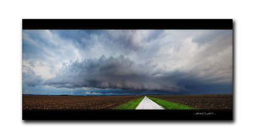
Image by StormRider93 | Into the Storm Photography
September 21, 2012:
Perhaps the most insane weather day of 2012 for both me as well as other local weather spotters, this Friday afternoon was anything but ordinary.
I first started off my day with college classes, and I felt like horrid hell…I currently have a terrible cold therefore getting up and doing normal things are a nightmare to do lol. After my classes were done for the day, I made my way home towards Ashmore (my place of peace/home) when I would analyze the Storm Prediction Center’s MD (mesoscale discussion/severe weather talk) mentioning a small-scale enhanced risk area of moderate to severe weather, where supercells were possible and could perhaps be tornadic across Central and East Central Illinois. These storms developed on and off through the day along what appeared to be an outflow boundary that developed directly in this same area just S of Oakland, Illinois earlier on in the day.
On another quick note, as I had mentioned before, a small-scale enhanced risk area is what local weather spotters thrive upon for the best action regarding severe weather. Think about it, if you live close by an area that has a very small area/limit for which the best storms are to occur, you are going to grab that opportunity by the horns and enjoy every minute of it!
Likewise, the day continued on and I made a trip up to Champaign County, Illinois where I would witness the neatest looking sub-supercell storm of my past 3 years of weather photography (you can see the action in my previous uploads – including a gorgeous rainbow as well.)
After finishing up the Champaign County intercept, I make my home towards Charleston at first to see some family for a quick minute, then I made my way home towards Ashmore yet again. As I was spacing out, cruising along Route 16, I look off to the North, to get a glimpse at what looked like another damn storm! I could see the low shelf cloud lit by ominous soft-lighting which created surreal violet and slate tones therefore I knew I needed to head up towards Oakland to catch the best view of this storm.
I got a weather alert text message stating a severe t-storm warning was in effect for Coles County until about 645pm CDT, then the NWS decided to increase warning duration for another half an hour or more, ’til 715-730 if I remember right.
Lastly, my final trip for this awesome day is seen here, with this panorama of an impressive 2-3 mile stretch from home glimpse of a beautiful severe thunderstorm/sub-supercell with a nice shelf cloud, and tilted updraft.
What. A. Day! September 21, 2012, this was my best day ever.
Enjoy! 🙂