
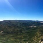
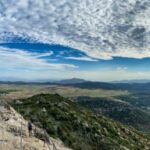
One of the more popular hikes in San Diego County, Stonewall Peak provides you with a 360° view of Cuyamaca Rancho State Park from its granite-topped summit. This moderate trail has beautiful vistas of some of the other nearby sights; Cuyamaca Peak, Oakzanita Peak, and Lake Cuyamaca, before reaching the top.
Distance: 3.8 miles
Time: 2 hours
Difficulty: Moderate
Elevation gain: 900 ft
Dogs: No
When to go: Year-round
Hours: Sunrise to sunset
Getting to the Trailhead
Stonewall Peak is located in the Cuyamaca Rancho State Park, just south of the town of Julian. The trailhead is located across from Paso Picacho Campground. There is a day-use area at the campground and it requires a fee (at the time of this report it was $ 10). Take the I-8 to Highway 79 and exit left toward Descanso and Julian. Pass through Descanso and keep left at the junction for Highway 80. Turn left into Paso Picacho campground, and the day-use area will be toward the right. Picnic tables and toilets are located here as well.
Hiking Stonewall Peak
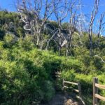
Begin your hike by heading toward the entrance to the Paso Picacho campground, directly across Highway 79 is the trailhead. Please take care in crossing the road. Once safely across, take a moment and read the hiking board for alerts (if you have not chatted with one of the friendly rangers already). The trail is well marked throughout and has only a couple of junctions to be aware of. Just past the hiking board, the trail splits into two; the left trail; the Cold Springs Trail, and the right trail; Stonewall Peak. Take the Stonewall Peak trail to begin your climb under the shade of some oak trees.

After about .16 miles, the service road that you have been hiking on will be blocked off, and your route will now switch to the standard trail that will take you off to the right. Stonewall Peak will be looming in front of you.
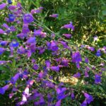
The trail will begin switchbacking up the western face of the peak. Along the way you will see reminders of the 2003 Cedar Fire that swept the area. Some burned trees still remain standing and young saplings are planted along the way. In addition, you will also see manzanita and ceanothus lining your route. Depending on the time of year, you could have a nice floral display.
Over the next 1.5 miles or so, you will gain much of the elevation to the summit. Make sure you stop and take in the views. Directly to your west will stand Cuyamaca Peak, San Diego’s second-highest peak at 6,512 feet. This is one of the peaks on the San Diego Six-Pack of Peaks Challenge. To the north of its tower topped summit sits Middle Peak then North Peak. When the trail offers a more northern view, you will be able to see Lake Cuyamaca and the nearby village.
You will come to your second junction on this hike just after a relatively flat section at about 1.9 miles in. The trail to the left will take you down the north side of the peak toward the Vern Whitaker Trail. You will want to take the trail to the left to continue your climb up toward Stonewall Peak.
The trail will encounter a small rocky section and become less defined here. Don’t worry, not only is it just a short section, but it also means you are almost at the top. The peak lies just to the southwest of this section. Once you see the handrail on the rocks, aim for that.

This section is best avoided if there is ice or snow, as the smooth granite can be very slippery. With that warning aside, climb the rocky staircase, with its helpful guard rail to the summit. Once there, railings help keep you secure atop the relatively small, but flat summit.

There are information panels to help you identify the local landmarks. To your north, you should be able to see Palomar Mountain, Lake Cuyamaca, and bits of Julian. To the west, Cuyamaca Peak will tower before you. Looking south, you will see East Mesa and Oakzanita Peak (one of my personal favorites in CRSP), and even Mexico. Finally, to the east, peaking past the Laguna Mountains, two of the western peaks of the Anza-Borrego desert can be seen; Granite and Whale Peak.

Once you are done soaking in the view, being mindful of other hikers who want to enjoy the view, you can simply retrace your route. If you are looking for a slightly longer return, at the last junction you encountered, take the other trail down to the Vern Whitaker Trail, then make a left onto the Cold Springs Trail to return you back to the original trailhead. This will extend the hike by about 1.2 miles. Once back at your car, you can enjoy a nice picnic, or drive a short distance into Julian for a meal.
Stonewall Peak or Cush-pi?
Stonewall Peak is named after the nearby Stonewall Mine which operated until 1906 and produced over 7,000 pounds of gold. The original mine was named after Confederate General Stonewall Jackson. After the Civil War, the name was shortened to just Stonewall. However, to the Kumeyaay tribe, this peak is known as Cush-Pi meaning “Sharp Peak”. They quarried Steatite (soapstone) from Cushi-pi and used it for a variety of purposes.
Stonewall Peak Trail Map
Download file: High_Point_Palomar_Mountain_from_Oak_Grove.gpx
Stonewall Peak Resources
- Cuyamaca Rancho State Park – official site